What Is Field Mapping and Why It Matters
Field mapping refers to the creation of visual layouts of farmland using tools like GIS software, drone imaging, and mobile mapping apps. Unlike manual surveying, it provides real-time spatial data using satellite imagery and geo-tagging. Platforms like Google Earth Engine and OpenStreetMap are helping farmers track land-use patterns with ease. This digital approach improves planning and resource use on every scale.
For smallholders and organic farmers, mapping is becoming indispensable in implementing climate-smart agriculture. With tools like the Kisan Drone, Fasal’s sensor networks, and CropIn’s digital twin models, farmers can precisely manage irrigation, pests, and crop cycles. It helps transition from guesswork to data-driven decision-making. This shift is vital for boosting productivity while conserving natural resources.
Field maps also support precision agriculture, where every seed, drop of water, or fertilizer input is optimized. Farmers use tools like SatSure, AgNext, and Skymet to overlay weather data, crop health, and field zones. The result is reduced input waste and increased yield per acre. These insights also enable early warnings for drought, pests, or soil issues.
Modern field mapping is a fusion of remote sensing, machine learning, and farmer intuition. Tools such as QGIS, OneSoil, and Plantix allow farmers to layer data like soil texture, slope, and sunlight exposure. This makes farming a visual, interactive, and evidence-based activity. It’s about farming smarter, not harder.
In the absence of mapping, many farmers apply inputs unevenly, causing nutrient loss and soil depletion. Solutions like DroneDeploy, PrecisionHawk, and Taranis detect issues before they escalate. A well-designed field map becomes a farmer’s live dashboard, guiding interventions like a GPS system for the land. This leads to healthier crops and lower costs.
Field mapping aligns with the vision of Digital India, enabling farmers to take control of their land data. Programs like PM-Kisan and Earth5R’s Blue Cities promote accessible, tech-driven farming. As climate risks grow, mapping is key to resilience and sustainability. It turns farmers into informed stewards of the land, ready for the future.
Satellite Imaging vs Ground Mapping: What Works Where
Satellite imaging provides large-scale views of farms using tools like Sentinel Hub, Google Earth Engine, and NASA Worldview. It helps track crop health trends, land degradation, and seasonal changes over time. Governments use this data to monitor drought zones and vegetation loss. While it offers regional insights, it lacks the detail needed for individual field decisions.
Ground mapping is ideal for zoomed-in, real-time data collection using drone surveys, GPS tools, and mobile apps. Farmers use platforms like DroneDeploy, Pix4Dfields, and Agisoft Metashape to create high-resolution maps of soil quality, irrigation lines, and pest hotspots. These tools support daily operations like planting and spraying. Ground-level data offers unmatched precision.
Satellite images work best in areas with limited access and large farms, such as parts of sub-Saharan Africa or hilly regions of Himachal Pradesh. They are useful in mapping climate risk and land use patterns. However, ground-based tools like QGIS and AgriGIS offer better control for small farms. The choice depends on scale, terrain, and available resources.
In waterlogged or sloped fields, drones equipped with LIDAR technology help map elevation and drainage systems. Platforms like AgriApp allow farmers to mark boundaries, record crop data, and track pest locations. These features are essential for customizing irrigation and preventing erosion. Ground mapping also supports organic certification documentation.
Satellites, however, excel when paired with AI for broader forecasting. Tools like SatSure, Planet Labs, and Radiant Earth convert images into early warning alerts for floods, droughts, or pest outbreaks. They power crop insurance platforms and climate risk maps. Combining satellite and ground data ensures both macro and micro accuracy.
The future lies in hybrid systems. Initiatives like Digital Green, Fasal, and e-Choupal merge ground reports with satellite insights to deliver real-time advice. These integrations support both farmers and policymakers. Matching the right technology to the right place ensures better results and fairer access.
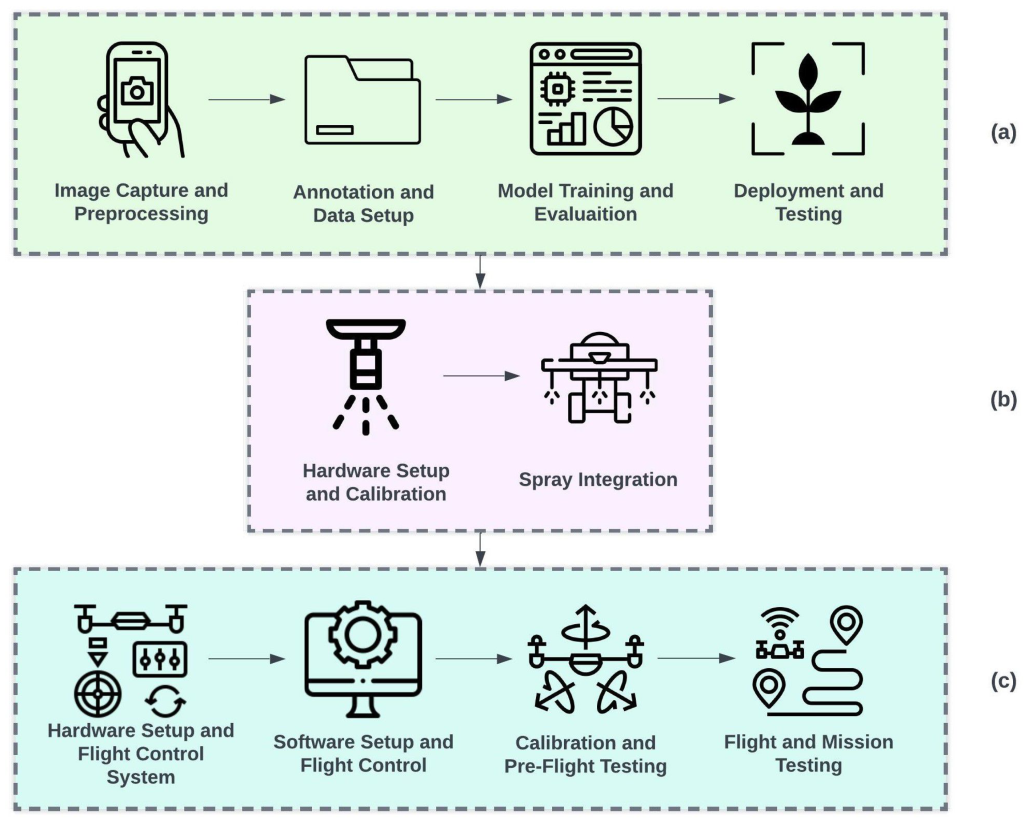
This infographic outlines the complete workflow of drone-based agricultural automation—from AI model training and spray system integration to flight control and mission testing.
It highlights the seamless coordination between software, hardware, and real-world deployment for precision farming.
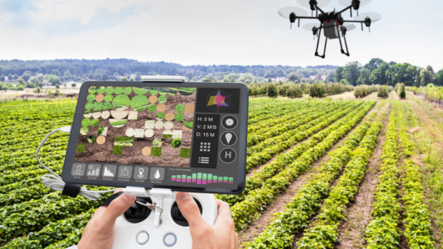
Drones, GPS, and Mobile Tools in Organic Farming
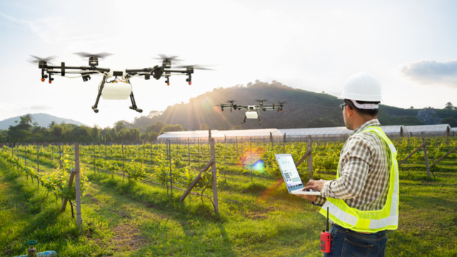
Drones have become a game-changer in organic farming by enabling real-time aerial surveys and multispectral imaging. These devices help monitor plant stress, canopy cover, and pest zones without disturbing the soil. Platforms like Pix4Dfields, DroneDeploy, and Skyspecs allow farmers to generate field-specific action maps. This ensures that organic practices stay efficient and non-invasive.
GPS-enabled devices are helping farmers map their fields with incredible accuracy. Tools like Garmin GPSMAP, Trimble’s AgGPS systems, and Emlid Reach RS2+ track boundaries, crop zones, and irrigation lines. This is particularly useful for managing organic inputs like compost, mulch, and biofertilizers. GPS tools reduce waste and allow for targeted input application.
Smartphones now act as mini control centers for organic farmers. Apps like Plantix, Kisan Suvidha, and AgriApp enable farmers to identify diseases, track weather, and log input records. These tools support compliance with organic certification standards. With mobile mapping, farmers can monitor fields daily without hiring expensive consultants.
Drones also help track weed infestation and reduce the need for manual weeding or herbicides. In organic farming, where chemical control is avoided, drone-based spraying of natural repellents like neem oil or biopesticides is gaining ground. Services like Garuda Aerospace and Agribotix are making such applications scalable and affordable. This bridges the gap between high-tech and natural farming.
GPS and drone tools also aid in designing crop rotation plans based on past yields and soil health. For example, a GPS-guided system can indicate nitrogen-depleted zones where legumes should follow cereals. Apps like CropIn, Fasal, and Farmonaut provide insights based on field history. This ensures organic rotations remain scientifically sound and economically viable.
Finally, mobile dashboards centralize data from drones, GPS, and sensors for easy access. Farmers use platforms like Climate FieldView, RML AgTech, and Krishify to make sense of multisource data. These tools support certification, traceability, and yield forecasting—all essential in organic markets. Digital integration helps small organic farms become both sustainable and profitable.
Use of Field Maps in Crop Planning and Rotation
Field maps allow farmers to visually track previous crop cycles, helping them make informed decisions about crop rotation. By using tools like QGIS, CropIn, and Fasal, farmers can log which crops were grown in which zones and how they impacted soil health. This data ensures balanced nutrient use across seasons. Mapping thus supports both soil conservation and yield stability.
In organic farming, rotation is essential for avoiding pest buildup and soil depletion. Platforms like AgriApp, OneSoil, and Krishify help farmers visualize field divisions and recommend ideal successor crops. For instance, legumes can be mapped to nitrogen-depleted zones after cereal crops. This strategic planning is critical for maintaining organic certification and soil integrity.
Field maps also help in planning intercropping strategies by identifying sunlight exposure, slope, and water availability. Tools like SatSure, DroneDeploy, and PrecisionHawk allow the creation of zones suitable for mixed cropping. This boosts land efficiency and pest resistance. Mapping improves biodiversity without complicating farm logistics.
With historical field maps, farmers can avoid repeating the same crop patterns that caused past failures. Using farm management software, mobile logging apps, or AI-based recommendations, farmers receive crop rotation alerts. This reduces dependence on memory or paper records. It’s a smarter, more consistent way to manage land over time.
Mapping supports rotational grazing in integrated systems where livestock and crops share land. Apps like PastureMap, TaroWorks, and FarmOS help organize rotational cycles with calendar syncing and grazing history. In organic setups, this prevents overgrazing and restores soil carbon. Maps guide the timing and location of each movement.
In rain-fed or monsoon-dependent regions, field maps help farmers schedule rotations based on water availability. Platforms like SWAT, SoilGrids, and GeoAgri integrate rainfall and soil data into rotation planning. This helps align crop choices with expected soil moisture. With climate volatility rising, such geo-data integration is becoming essential.
How Field Mapping Helps Reduce Input Waste
Field mapping helps farmers identify exactly where to apply water, fertilizer, or organic inputs, reducing unnecessary use. Tools like DroneDeploy, Pix4Dfields, and QGIS generate precise maps of input needs. These maps prevent over-application in fertile zones and under-treatment in weak patches. This saves money and improves ecological balance.
With data from soil sensors, moisture probes, and mobile mapping apps, farmers can target inputs like compost or neem oil only where needed. Platforms such as Fasal, CropIn, and Farmonaut allow for remote monitoring of soil zones. This prevents blanket spraying or over-fertilizing. It’s resource-efficient and supports organic integrity.
Pest control becomes more accurate with mapping. Tools like Taranis, Skyglyph, and Agremo use drone imagery to spot early signs of infestation. Instead of spraying entire fields, farmers can treat only the affected zones with biopesticides like neem-based formulations or bacillus thuringiensis. This minimizes chemical load while protecting yield.
Irrigation systems also benefit from mapped efficiency. Platforms like Rachio, SmartFarm, and Jain Irrigation’s Smart Irrigation help design zone-specific watering schedules based on topography and soil moisture. This prevents water runoff and ensures hydration only where required. It also reduces pump usage and electricity consumption.
Organic inputs like vermicompost, bone meal, or bio-slurry are often wasted when spread uniformly. Field maps from tools like OneSoil, AgriApp, and Climate FieldView help calculate precise application amounts. This improves input efficiency while maintaining soil health. It also makes nutrient budgeting more predictable.
By integrating drone maps with satellite insights, farmers can act before problems spread. Solutions from SatSure, Radiant Earth, and Digital Green provide predictive alerts based on environmental changes. These early warnings allow minimal, targeted input responses. Mapping thus becomes a core tool for waste-free, resilient farming.
Integrating Soil and Water Data for Better Results
Field mapping becomes far more powerful when it incorporates detailed soil data from sources like SoilGrids, ISRIC, and India’s Soil Health Card scheme. These databases help visualize soil pH, nutrient levels, and organic carbon content across different zones of a farm. When mapped through tools like QGIS or CropIn, farmers can plan tailored interventions. This makes soil management far more targeted and effective.
Mobile-based soil testing devices such as Krishi Rasayan’s Soil Test Kits and NutriSens allow farmers to instantly assess micro-zones for deficiencies. These results can be integrated with mapping platforms like Fasal or Farmonaut to visualize zones of nutrient stress. With this information, inputs like compost or organic phosphorus can be applied only where needed. This reduces both cost and environmental burden.
Water data, especially from rainfall sensors and satellite-based evapotranspiration trackers, adds another vital layer to maps. Tools such as SWAT+, AquaCrop, and SmartFarm help forecast water availability across different seasons. Integrating this data into maps helps design optimal irrigation layouts. This is especially useful for rainfed farms and drought-prone zones.
Groundwater mapping is critical in areas facing water table depletion. Using CGWB maps, Bhuvan Water Resources, and mobile well sensors, farmers can see where to drill borewells or harvest rainwater. These groundwater maps, when overlaid with soil data using tools like GeoAgri, can suggest high-return irrigation investments. Mapping reduces trial-and-error in expensive infrastructure decisions.
Soil moisture sensors such as Teros 12 or Irrometer tensiometers feed real-time data into platforms like Climate FieldView and SatSure Sparta. This helps in dynamically adjusting watering schedules or delaying fertilizer application. Combining this with soil texture data prevents both leaching and over-irrigation.
Integrating all this information into a unified digital map—soil fertility, moisture levels, and water flow—creates a complete picture of farm health. Apps like AgriApp, Plantix, and RML AgTech offer easy visualization dashboards. This empowers farmers to make smarter, data-backed decisions. Soil and water synergy through mapping directly boosts crop resilience and profitability.
Case Studies from India and Africa
In Maharashtra, India, Earth5R partnered with local communities to deploy low-cost drones and smartphones for field mapping in semi-arid zones. Farmers used tools like Fasal and Plantix to monitor soil moisture and pest spread. Through this initiative, water usage dropped by 30%, and organic yields improved. The success was amplified by India’s Soil Health Card integration and Digital India support.
Punjab’s organic cotton farmers have used CropIn to digitally map fields and receive crop-stage-specific alerts. With real-time imaging from DroneDeploy and Pix4Dfields, they minimized pesticide usage and enhanced traceability for export. Collaborations with APEDA helped these farmers gain organic certification. This shows how technology can uplift local economies through sustainable practices.
In Kenya, Digital Green and One Acre Fund introduced digital mapping in rural cooperatives. Using mobile GPS apps and open-source platforms, smallholders created field records linked to crop histories. These maps guided compost distribution and flood-resilient cropping. Training local youth as mapping facilitators ensured lasting community ownership.
Hello Tractor, operating across Nigeria and Kenya, uses geo-tagged maps and fleet tracking to offer tractors on demand. Paired with drone-based scouting, farmers know when and where to till, avoiding redundant plowing. This has reduced fuel waste and improved soil structure. Their model shows how mapping can modernize mechanization for even one-acre farms.
In Uganda, Radiant Earth Foundation is providing satellite data to NGOs supporting agroforestry projects. Farmers overlay these maps with on-ground surveys using tools like FarmOS to select tree species for degraded zones. It links carbon sequestration goals with practical land use. These projects align with FAO’s Climate-Smart Agriculture framework.
What unites these case studies is the integration of mapping with training, mobile apps, and community participation. From ITC e-Choupal in India to AgUnity in Africa, these models show that democratized mapping is feasible at scale. Field maps become not just tools, but enablers of resilience, equity, and innovation.
Role of Youth, Startups, and Tech Hubs
Across India and Africa, young innovators are building the backbone of agri-mapping ecosystems. Startups like Fasal, CropIn, and Farmonaut were launched by young entrepreneurs aiming to make precision farming accessible. These platforms use drones, AI, and remote sensing to simplify decision-making. Their success shows how the youth can bridge agriculture and data science effectively.
Tech hubs like T-Hub in Hyderabad and iHub in Nairobi serve as incubators for agri-startups. They provide mentorship, funding, and exposure to satellite data tools like Sentinel Hub and Google Earth Engine. By hosting hackathons and pilot programs, these centers push innovation in soil mapping, pest forecasting, and resource planning. Their local focus ensures relevance on the ground.
Youth-led training programs are also helping farmers adopt mapping tools. Initiatives like Digital Green, e-Krishi Samvad, and AgriApp Academy are teaching rural youth to use QGIS, GPS loggers, and drone apps. These trained youth often become agri-tech service providers themselves, generating employment while improving local farm resilience.
Innovative mapping startups are solving region-specific problems. For instance, SatSure offers climate risk insights tailored to Indian microclimates, while Zenvus in Nigeria maps soil fertility with handheld sensors. Their tools cater to different languages, soil types, and connectivity levels. These hyperlocal solutions are key to ensuring equity in digital agriculture.
Agri-focused youth collectives like Krishi Vigyan Kendras (KVKs) and YouthAgSummit are integrating field mapping into grassroots campaigns. From soil health mapping to water budgeting, young people are leading demonstrations using mobile-based GIS and low-cost drones. Their involvement makes tech adoption socially contagious and scalable.
Finally, the rise of open innovation platforms like AgriHack and Hack4Farming allows youth globally to co-develop mapping solutions. These platforms crowdsource new ideas and test them in real farm environments. By tapping youthful creativity and urgency, the field mapping movement becomes more inclusive, fast-paced, and impact-driven.
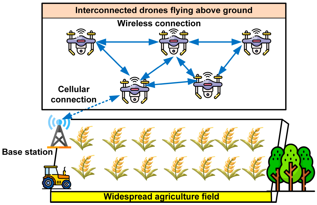
This infographic illustrates a network of interconnected drones communicating wirelessly while monitoring a widespread agricultural field. The system connects to a base station via cellular signals, enabling real-time data collection and precision farming operations.
Cost and Access Challenges for Smallholders
Despite the benefits, high costs remain a major barrier for smallholders trying to adopt field mapping. Tools like drones, RTK GPS systems, and premium platforms like Pix4Dfields can be prohibitively expensive. Many farmers lack upfront capital or access to financing. Without models like pay-per-use drone services or community-owned mapping devices, these innovations remain out of reach for millions.
Internet connectivity is another major hurdle in rural areas. Many mapping tools rely on high-speed data or cloud syncing, which can be unreliable in remote zones. Platforms like Farmonaut, OneSoil, and GeoAgri offer offline functionality or lightweight versions for low-bandwidth areas, but gaps remain. Digital infrastructure must expand in tandem with agri-tech rollouts to ensure true accessibility.
Lack of digital literacy is also a major constraint. While youth may adopt tools quickly, older or less-educated farmers may struggle with apps, GPS logs, or satellite data interpretation. Programs like Digital India, AgriApp Academy, and Krishi Vigyan Kendras are trying to close this gap through training. However, without localized, visual content in regional languages, adoption remains patchy.
Another concern is ownership of data and privacy. Farmers are often unsure how their mapped land and crop data is used or stored. While platforms like CropIn and RML AgTech have data protection policies, many free tools don’t clarify usage rights. There’s growing need for transparent, farmer-friendly data governance models that build trust and ensure fair benefit-sharing.
Fragmented land holdings also make mapping more complex and costly. In India, where many farmers cultivate plots under 2 hectares, drone flights or GPS logging become logistically intensive. Some initiatives like PM-KISAN Drone Campaigns and ITC e-Choupal are piloting collective mapping models, but these are still limited. Economies of scale must be built through cooperatives and rural tech hubs.
To make mapping truly inclusive, policies must support subsidized tech access. Government schemes, CSR efforts, and NGO-led training—like those run by Earth5R, Digital Green, and FAO—are critical. Field mapping should be viewed not as a luxury but as a basic agricultural input, especially in the face of climate change.
Conclusion: Field Mapping for Farmers- How Data, Drones, and Design Can Boost Yields and Cut Waste
Field mapping is no longer just a scientific tool—it’s becoming the everyday compass of the modern farmer. With platforms like DroneDeploy, QGIS, and Fasal, even smallholders can visualize their soil, crops, and inputs in ways that were once unimaginable. As climate change and erratic weather threaten productivity, mapping offers a way to adapt, predict, and protect. It empowers farmers with clarity instead of guesswork.
The synergy of data from satellites, drones, and ground surveys allows for holistic land management. Tools like CropIn, SoilGrids, and SmartFarm help in rotating crops smartly, reducing input waste, and improving water use. This isn’t just about boosting yields—it’s about protecting ecosystems. Sustainable choices become easier when insights are visual and immediate.
What’s most promising is how youth, startups, and local innovators are making this tech farmer-friendly. From Earth5R’s citizen hubs to training programs by Digital Green and Krishi Vigyan Kendras, a grassroots digital movement is growing. These efforts ensure that innovation doesn’t remain locked in labs but thrives in the hands of those who grow our food. Democratization of data is now a tangible reality.
As we move forward, the mission must be to make mapping universal, open-source, and embedded in every aspect of farming. With the support of initiatives like Digital India, PM-Kisan Drone Yatra, and global movements like FAO’s Digital Agriculture, this vision is achievable. When every farmer can map their land, they also map their future—one decision, one season, and one harvest at a time.
Frequently Asked Questions: Field Mapping for Farmers- How Data, Drones, and Design Can Boost Yields and Cut Waste
What is field mapping and how does it benefit small-scale farmers?
Field mapping is the process of visually recording and analyzing farm data such as soil type, crop health, and topography. For small-scale farmers, it enables targeted decision-making, reduces guesswork, and boosts both efficiency and yield.
How does satellite imaging compare to on-ground mapping methods in terms of accuracy?
Satellite imaging provides large-scale coverage and is useful for monitoring trends over time, but it lacks the high resolution of on-ground methods like drones or GPS-based mapping, which offer precise, field-level insights.
In what situations is drone-based mapping more effective than satellite-based mapping?
Drone-based mapping is ideal when detailed imaging is required—such as for small plots, hilly terrains, or pest monitoring—where satellite resolution may fall short or cloud cover might obscure imagery.
What role do GPS tools and mobile apps play in organic farming?
GPS devices help farmers accurately define plot boundaries, while mobile apps offer disease detection, weather alerts, and input recommendations—ensuring compliance with organic standards and improving productivity.
How can field mapping support effective crop rotation in sustainable farming systems?
By recording what was planted where and when, field mapping helps plan crop rotation that replenishes soil nutrients and breaks pest cycles, improving long-term soil fertility and reducing dependency on chemicals.
Why is field mapping important for reducing input waste like fertilizers and water?
Mapping identifies exact areas that need inputs, preventing overuse and saving costs. It enables precision application of compost, water, and biofertilizers, reducing environmental impact and resource waste.
How do soil health maps help farmers make better agricultural decisions?
Soil health maps show pH, organic matter, and nutrient levels across the farm, guiding input decisions and crop selection. This prevents over-fertilization and supports regenerative soil management.
Can farmers use water availability maps to plan irrigation more efficiently?
Yes, water maps reveal soil moisture, drainage patterns, and seasonal water availability, helping farmers plan irrigation schedules, install efficient systems, and reduce water loss in dry zones.
What are some successful field mapping initiatives from India and Africa?
Projects by Earth5R in Maharashtra, CropIn in Punjab, and Digital Green in Kenya have empowered farmers with drones and apps, leading to reduced input use, better yields, and improved climate resilience.
How has mapping technology improved yields and sustainability for smallholder farmers?
By offering real-time data on soil health, crop stress, and pest risks, mapping enables timely interventions. This results in improved productivity, lower input costs, and long-term ecological balance.
How are youth and agri-tech startups contributing to field mapping innovation?
Young entrepreneurs are creating mapping tools that are mobile-based, affordable, and localized. Startups like Fasal, Farmonaut, and Zenvus are helping integrate AI, GPS, and IoT into everyday farming.
What role do tech hubs and digital training programs play in spreading mapping tools?
Tech hubs such as T-Hub and iHub provide mentorship and testing grounds for agri-tech. Training programs by Digital Green and AgriApp Academy teach farmers and rural youth how to use mapping tools effectively.
Are there low-cost mapping solutions available for farmers with limited budgets?
Yes, open-source platforms like QGIS and mobile apps like Plantix and AgriApp offer affordable entry points. Community-owned drones and pay-per-use mapping services also help reduce individual costs.
How can farmers in remote areas use mapping tools without reliable internet access?
Offline GPS tools, preloaded maps, and lightweight mobile apps designed for low connectivity—like OneSoil and Farmonaut—allow mapping even in areas with poor internet infrastructure.
What are the main digital literacy challenges in adopting field mapping technology?
Many farmers are unfamiliar with GIS tools or struggle with language barriers in English-only apps. Without visual aids or regional content, it becomes difficult for first-time users to navigate mapping platforms.
How can mapping tools be adapted to local languages and farming knowledge systems?
By incorporating multilingual support, visual guides, and voice-enabled navigation, platforms can align better with regional dialects and practices. Community-based demonstrations also help bridge knowledge gaps.
Why is collective access to drones and GPS tools important for smallholder communities?
Shared ownership models reduce costs and make advanced tools accessible to entire farming communities. It also builds cooperation, allowing knowledge-sharing and more equitable tech distribution.
How can field mapping initiatives ensure inclusivity for women and tenant farmers?
By designing training specifically for marginalized groups and involving them in early stages, mapping projects can empower those often excluded from tech-driven agriculture due to land or resource constraints.
What open-source tools are available for farmers who want to start mapping their land?
Free tools like QGIS, OpenStreetMap, and ODK Collect allow farmers to draw boundaries, tag crop zones, and monitor field activities using just a smartphone and basic GPS device.
How can governments and NGOs help make field mapping accessible to every farmer?
Through subsidies, digital literacy programs, and community tech centers, stakeholders can make mapping an essential part of agriculture. Initiatives like IDEA, e-Choupal, and FAO’s Digital Villages are already doing this.
Call To Action: Field Mapping for Farmers- How Data, Drones, and Design Can Boost Yields and Cut Waste
Field mapping is no longer a futuristic concept—it’s a practical, powerful tool that every farmer should have access to. Whether you’re a smallholder in a remote village or part of a large farming collective, the ability to visualize your land, understand your soil, and track your inputs can completely transform how you grow. Now is the time to move beyond guesswork and embrace data-driven farming as a right, not a privilege.
If you’re a policymaker, agri-tech entrepreneur, or CSR leader, this is your moment to invest in scaling these tools. Affordable mapping devices, open-source software, and grassroots training programs can create a ripple effect of productivity, sustainability, and rural empowerment. Make field mapping a core part of rural development and climate-resilient agriculture strategies.
For educators, trainers, and NGOs, bringing these tools to the field means equipping farmers with independence and foresight. Build community hubs, conduct mapping demonstrations, and train youth to be agri-digital ambassadors. Empower farmers not just to adapt to change—but to lead it.
And if you’re a farmer—take the first step. Start small, with your phone or a community GPS tool. Map your land, record your crops, learn your soil’s needs. The future of farming is already here. All it takes is your willingness to map it out, one field at a time.
~Authored by Barsha