
The world is facing an escalating waste crisis, with urbanization and consumerism generating unprecedented volumes of solid waste. According to the World Bank, global annual waste generation is expected to reach 3.4 billion tonnes by 2050, up from 2.01 billion tonnes in 2016.
This surge poses severe threats to environmental sustainability, public health, and urban infrastructure—particularly in low- and middle-income countries where waste management systems are often inadequate. Open dumping, unsegregated waste, and unregulated landfills not only contaminate ecosystems but also release toxic emissions and exacerbate climate change.
In response to these challenges, innovative solutions are emerging that leverage technology and data to transform how we manage waste. Waste mapping—the systematic collection, analysis, and visualization of waste data—is one such approach.
By geotagging waste locations, classifying types of waste, and understanding spatial waste patterns, waste mapping offers a powerful, evidence-based lens to identify problems and design targeted interventions. It moves beyond reactive cleanup to proactive planning and resource allocation, turning waste into actionable information.
At the forefront of this movement is Earth5R, a Mumbai-based environmental organization committed to driving local sustainability. The organization combines technology, citizen science, and community engagement to address urban waste challenges. Through its waste mapping initiatives, Earth5R mobilizes volunteers to collect real-time waste data across diverse locations.
This data is then integrated into cloud-based platforms for further analysis. Based on these insights, Earth5R develops strategic actions tailored to specific waste challenges. These actions include cleanup operations, awareness campaigns, policy advocacy, and circular economy interventions.
This article explores how Earth5R’s integrated waste mapping model unites scientific rigor with participatory approaches. It also highlights the importance of grassroots insights in creating impactful environmental solutions. When harnessed effectively, data becomes a powerful driver of systemic, scalable, and sustained change—far beyond short-term cleanups.
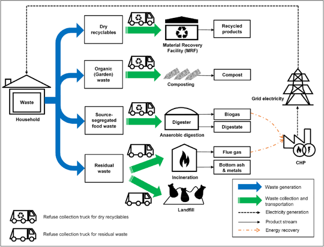
This flowchart illustrates a household waste management system where waste is segregated into recyclables, organic, food, and residual waste for processing through recovery, composting, digestion, and incineration. It highlights how different waste streams contribute to recycled products, compost, biogas, and electricity, promoting sustainability and resource recovery.
Understanding Waste Mapping
Waste mapping is a scientific and systematic approach to identifying, categorizing, and visualizing waste patterns within a geographic area. It involves collecting data on the type, quantity, and location of waste, and then using this information to create spatial maps that reveal trends and problem zones. The core idea is to make the invisible problem of waste visible and quantifiable, thereby enabling evidence-based interventions.
Waste mapping serves as a foundation for designing effective waste management strategies, particularly in urban areas where informal dumping and inconsistent waste services are common. Around the world, various waste mapping initiatives have demonstrated the power of data in addressing environmental challenges.
For example, the World Bank’s What a Waste 2.0 platform aggregates solid waste data from hundreds of cities globally to inform policymaking. In Indonesia, the Kota Kita project mapped informal settlements to assess waste flows and service gaps, helping municipalities identify underserved areas.
In Kenya, the UN-Habitat Waste Wise Cities Tool uses digital mapping to evaluate waste infrastructure and leakage points, leading to improved service planning. These initiatives highlight how mapping can not only quantify waste but also guide resource allocation and community engagement.
Earth5R’s approach builds upon these global efforts but is uniquely tailored to the Indian context, where informal waste systems and unregulated dumping present complex challenges. The organization’s waste mapping methodology is built on four key components that ensure a holistic understanding of waste dynamics.
Data collection is carried out through on-ground surveys conducted by trained volunteers and local community members, who identify and document waste hotspots. This is followed by geotagging, where each waste site is marked with GPS coordinates to create precise spatial maps. Next, material classification is performed, categorizing waste into types such as plastic, organic, hazardous, and recyclable materials to enable targeted interventions.
Finally, temporal mapping tracks how waste accumulation and disposal patterns change over time, allowing Earth5R to measure seasonal trends, evaluate the impact of cleanups, and plan long-term solutions. The scientific rationale behind waste mapping lies in its ability to provide data-driven diagnostics.
According to a 2022 study published in the Journal of Urban Environmental Management, cities that employ spatial waste mapping demonstrate significantly higher efficiency in managing their resources. These cities are also more effective in policy formulation, as decisions are grounded in accurate, location-specific data. Another study by the International Solid Waste Association (ISWA) supports this finding.
It emphasized that localized data collection enables more tailored and context-specific waste management solutions. These solutions not only improve environmental outcomes but also deliver strong economic benefits. Waste mapping, therefore, functions as more than just a monitoring tool—it is a strategic enabler for circular economy practices, community involvement, and flexible urban planning.
Earth5R’s Waste Mapping Framework
Earth5R’s waste mapping model is built on a robust, participatory, and tech-enabled framework that bridges grassroots engagement with cutting-edge data systems. At the core of this approach is the belief that sustainable waste management solutions must be both scientifically sound and community-driven.
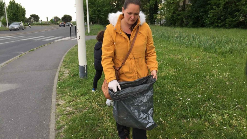
Earth5R collects waste data through a decentralized system that empowers citizen volunteers to serve as data collectors and environmental stewards. These volunteers are trained to identify waste hotspots, classify types of waste, and document local challenges. They use mobile applications developed or adapted by Earth5R to upload data, photographs, and field notes in real time.
This information is stored on digital platforms, where it is cleaned, verified, and analyzed by Earth5R’s core team. A defining feature of Earth5R’s methodology is the use of Geographic Information Systems (GIS), Artificial Intelligence (AI), and cloud computing. GIS is used to geotag waste locations and build high-resolution waste maps of urban and peri-urban zones.
AI helps automate the classification and clustering of data to identify patterns, such as frequent dumping areas, illegal waste accumulation, and zones with poor segregation practices. Cloud-based infrastructure ensures that the data is accessible, scalable, and secure, allowing stakeholders—from municipal bodies to citizen groups—to use insights for decision-making and action planning.
These technologies enable Earth5R to handle large volumes of data with speed and efficiency. At the same time, they retain the granularity required for hyperlocal decision-making. Earth5R applies this system to map various categories of waste across diverse urban environments. One major focus is household waste, which provides insight into domestic segregation habits and disposal behavior.
The organization also maps public space waste, such as litter found in parks, markets, roadsides, and other shared areas. Another key category is industrial and construction waste, which is often unmanaged, especially in informal or transitional zones. Additionally, Earth5R tracks waterway waste, documenting the plastic and organic pollutants contaminating rivers, lakes, and coastal regions.
This broad and layered categorization enables Earth5R to build a comprehensive waste profile for each locality, identifying the sources, types, and behavioral drivers behind waste generation. Crucially, Earth5R supplements this quantitative data with qualitative insights gathered through community interviews, focus groups, and stakeholder meetings.
These engagements uncover behavioral patterns, cultural attitudes toward waste, and barriers to proper disposal or segregation. By integrating these insights with spatial data, Earth5R creates a more holistic understanding of the local waste ecosystem. For example, a hotspot might not only be a result of logistical inefficiencies but also due to a lack of awareness or absence of community infrastructure.
The effectiveness of this hybrid model is supported by global research. A 2021 paper in the International Journal of Waste Resources found that waste management initiatives combining citizen science with digital mapping tools showed a 40% improvement in community compliance and a 35% increase in intervention accuracy compared to traditional approaches.
Similarly, a UN-Habitat report on urban innovation emphasized that participatory data collection combined with technology enhances transparency, boosts local ownership, and increases the sustainability of environmental interventions. By merging technology and community engagement, Earth5R’s waste mapping framework not only diagnoses problems but also catalyzes action, creating a scalable blueprint for waste-positive cities.
Turning Data into Action: Localized Impact
The strength of Earth5R’s waste mapping model lies not just in the collection of data, but in how that data is translated into localized, high-impact interventions. By visualizing waste patterns and identifying hotspots, Earth5R empowers communities, institutions, and city authorities to make informed decisions and implement targeted cleanup and waste reduction strategies.
This actionable intelligence ensures that resources are deployed efficiently and interventions address the root causes of waste mismanagement. One compelling example of this approach can be seen in Mumbai’s M-East Ward, an area characterized by informal settlements and limited waste infrastructure.
Shivaji Nagar, Mumbai
Through community-driven waste mapping, Earth5R identified over 35 undocumented dumping sites in and around the Shivaji Nagar slum. The data revealed that most of the waste originated from local vendors and uncollected household refuse. This insight enabled Earth5R to partner with the local municipality and design a community waste segregation and cleanup campaign.
Mobile waste collection units were introduced to serve previously unserviced zones, and awareness drives were launched in collaboration with local schools and self-help groups. Within six months, the area saw a 40% reduction in illegal dumping, and over 2,000 households adopted basic segregation practices.
Aundh-Baner, Pune
In another instance, Earth5R’s waste mapping project in Pune played a key role in influencing city-wide policy. The mapping exercise in the Aundh-Baner ward revealed low segregation compliance despite access to municipal services. Data collected from residential societies and public bins indicated that over 60% of recyclable waste was being landfilled due to poor segregation at source.
Earth5R used this evidence to engage directly with Resident Welfare Associations (RWAs) and the Pune Municipal Corporation. They co-developed an urban waste action plan that included citizen workshops, door-to-door outreach, and school-led awareness programs. Based on the success of the pilot, the municipal authority amended its ward-level waste bylaws, mandating segregation training and compliance monitoring for RWAs.
Within a year, the ward recorded a 30% increase in household segregation compliance and a marked drop in landfill-bound waste. These case studies demonstrate how data-driven interventions help mobilize a wide spectrum of local stakeholders. Earth5R actively collaborates with municipal bodies, who use mapped data to plan infrastructure upgrades and optimize collection routes.
Resident Welfare Associations (RWAs) and educational institutions are engaged through community workshops and environmental audits based on mapping outcomes. Even local businesses and informal vendors are involved in behavioral change programs, especially in markets where packaging and food waste contribute to significant pollution.
By presenting clear, localized data, Earth5R transforms waste from an abstract issue into a visible, solvable community problem, enabling broad-based participation. The benefits of such data-driven local action are also supported by academic research. A 2020 study published in Waste Management & Research found that neighborhoods using spatial and behavioral waste data for interventions had much better results.
These areas showed a 52% higher waste recovery rate over a two-year period compared to those using generic, non-targeted approaches. The study also highlighted the value of citizen participation in strengthening outcomes. When combined with data analytics, community engagement led to reduced costs and better policy compliance.
It also resulted in stronger local ownership of waste management initiatives. Another study by UNEP emphasized that the success of urban environmental programs depends heavily on hyperlocal data, which improves relevance, flexibility, and accountability.
By turning waste data into action, Earth5R is not only cleaning up cities but also building local capacity for sustained environmental stewardship. Their model proves that when communities are equipped with the right data and tools, they can become powerful agents of change in the fight against urban waste.
Waste Mapping for Policy Influence and Replicability
Beyond community interventions, Earth5R’s waste mapping initiatives are now being used to influence policy and support urban planning. These efforts go beyond cleanups to shape how cities think about waste. Earth5R compiles localized, data-rich waste maps and detailed analytical reports. With this information, it engages proactively with municipal corporations, ward officers, and urban planners.
The reports are visual and evidence-based, making them easy to interpret and apply. They offer actionable insights into waste distribution, infrastructure gaps, and citizen behavior, enabling smarter and more targeted policymaking. A notable instance of this is Earth5R’s collaboration with the Thane Municipal Corporation (TMC).
After mapping waste hotspots in three administrative wards, Earth5R shared its findings in the form of a comprehensive report highlighting patterns of illegal dumping, low segregation zones, and under-serviced neighborhoods. The TMC used this data to revise its solid waste management routes, allocate additional sanitation workers, and pilot a community-driven waste segregation campaign.
Similarly, in Nashik, Earth5R’s data helped urban planners identify overburdened landfill zones and propose the development of decentralized composting units in peri-urban areas. These successful collaborations underscore the scalability and replicability of Earth5R’s model in other Indian cities and across countries in the Global South, where unplanned urbanization and limited waste infrastructure are common challenges.
The core components of Earth5R’s model—community participation, geospatial technology, and cloud-based platforms—are both adaptable and cost-effective. This makes the approach well-suited for replication in municipalities that operate with limited financial resources. Pilot programs inspired by Earth5R are already underway in smaller Indian towns like Chhatrapati Sambhaji Nagar and Bhopal.
Likewise, stakeholders in Sri Lanka and Nepal have shown interest in adopting similar grassroots-led, data-driven waste management frameworks. From a research perspective, the importance of data transparency in policymaking is widely documented. A 2021 paper in the Journal of Urban Affairs emphasized that data accessibility and public engagement are critical to the success of inclusive urban governance.
Transparent, community-generated data not only builds public trust, but also allows for greater accountability and responsiveness from government agencies. In Earth5R’s case, the availability of real-time, localized waste data creates a feedback loop between citizens and policymakers, fostering co-created solutions rather than top-down directives.
Ultimately, Earth5R’s work demonstrates how waste mapping is not merely a tool for documentation—it is a strategic lever for policy influence, systemic reform, and scalable change.
Challenges and Future Scope
While Earth5R’s waste mapping model has demonstrated strong results, it also faces several operational and systemic challenges. One of the foremost issues is ensuring the accuracy and consistency of data collected by citizen volunteers. Given that the model relies heavily on community participation, there can be variation in how data is recorded—particularly in categorizing waste types, estimating volumes, or tagging GPS coordinates.
Moreover, sustaining long-term volunteer engagement requires continuous training, motivation, and quality control, which can be resource-intensive. Another challenge lies in technological infrastructure and institutional collaboration. In some low-income or semi-urban regions, limited access to smartphones, internet connectivity, or digital literacy can constrain the use of mobile data collection tools.
Besides, resistance from local authorities—whether due to political inertia, bureaucratic silos, or fear of public accountability—can delay or block data-driven interventions. Despite the clarity and utility of waste maps, some municipal bodies are hesitant to acknowledge unofficial data or allow external organizations to influence urban planning. To address these issues, Earth5R has developed several strategies for resilience and adaptability.
For instance, Earth5R uses standardized data collection protocols to ensure consistency in the information gathered. It also incorporates simplified mobile interfaces, which help minimize user error and enhance data accuracy. To build grassroots capacity, Earth5R provides structured training sessions for volunteers. These sessions are often conducted in collaboration with local NGOs or educational institutions.
On the governance side, Earth5R fosters trust by sharing data transparently with local authorities. The organization frames its role as collaborative rather than confrontational, positioning itself as a partner in innovation instead of a critic of municipal inefficiency. Looking ahead, Earth5R is exploring technological innovations that can enhance both the scale and precision of its waste mapping model.
Potential future tools include satellite imagery integration to track macro-level waste movements, IoT-based sensors in bins and waterways for real-time monitoring, and blockchain systems for verifying waste recovery across the recycling value chain. These technologies could help automate data validation and provide immutable, decentralized records of waste flow—boosting transparency and traceability.
Emerging research in waste tech supports Earth5R’s trajectory. Studies published in Environmental Monitoring and Assessment and Smart Cities journals highlight the increasing use of AI, remote sensing, and participatory GIS in shaping the future of waste management. These studies emphasize the growing convergence of technology and community-based approaches.
Earth5R’s hybrid model, which integrates citizen engagement with cutting-edge tools, aligns perfectly with these trends. This positioning places Earth5R at the forefront of innovative waste management solutions. As a result, the organization is poised to be a leader in the future of sustainable urban ecosystems.
Redefining Waste: From Trash to Data-Driven Transformation
As urban populations continue to grow and waste generation intensifies, effective waste management has become a cornerstone of the urban sustainability movement. Waste mapping plays a critical role in this effort by providing the necessary data-driven insights that inform smarter, more effective interventions.
By leveraging geospatial technology and citizen science, waste mapping empowers local communities, governments, and organizations to move from reactive waste management to proactive, strategic action. It enables decision-makers to identify waste hotspots, track patterns, and optimize resource allocation—ultimately leading to more sustainable urban environments.
Earth5R exemplifies this approach by seamlessly connecting data with real-world impact. Through its community-driven waste mapping initiatives, the organization has been able to identify key areas for intervention, design targeted cleanup operations, and influence waste management policies. This data-driven model has proven that when communities are empowered with accurate, real-time data, they can drive meaningful, scalable change.
Whether through enhancing waste segregation, improving recycling practices, or influencing municipal waste policies, Earth5R’s waste mapping initiatives have had a transformational effect at both the local and policy levels. Looking ahead, scaling models like Earth5R’s could redefine how the world views waste.
Rather than simply seeing waste as an unfortunate byproduct of human activity, these models treat it as valuable information. This information can reveal hidden patterns, inefficiencies, and opportunities for improvement. By viewing waste through the lens of data, we can create more sustainable cities and economies.
This shift enables us to not only manage waste more effectively but also turn it into a resource. This new perspective has the potential to transform the future of waste management. Ultimately, it makes waste an integral part of circular economies and sustainable urban living.
FAQs on Waste Mapping for Change: How Earth5R Uses Data to Drive Local Action
What is waste mapping?
Waste mapping is the process of collecting, analyzing, and visualizing data related to waste generation, distribution, and management in a specific area. It helps identify hotspots and optimize waste management strategies.
How does Earth5R use waste mapping?
Earth5R uses waste mapping to collect data from local communities, volunteers, and technology to identify waste patterns, inform clean-up operations, and influence urban waste management policies.
Why is waste mapping important for urban sustainability?
Waste mapping provides insights that can optimize waste management systems, reduce inefficiencies, and contribute to more sustainable urban development by identifying waste hotspots and improving resource allocation.
How does Earth5R collect waste data?
Earth5R collects waste data through citizen volunteers who use mobile apps and digital platforms to survey waste hotspots, classify materials, and geotag waste locations.
What types of waste does Earth5R map?
Earth5R maps various types of waste, including household waste, public space waste (e.g., litter in parks and streets), industrial waste, and waterway waste (e.g., plastic and organic pollutants).
How does Earth5R engage the community in waste mapping?
Earth5R engages the community by training local volunteers, organizing awareness campaigns, and involving them in data collection and mapping activities.
How is waste data used by Earth5R to drive local change?
The collected data is analyzed and used to design targeted interventions, such as cleanup operations, awareness programs, and policy advocacy efforts.
What role does technology play in Earth5R’s waste mapping model?
Earth5R uses advanced technologies like GIS (Geographical Information Systems), mobile apps, cloud-based platforms, and AI to collect, analyze, and share waste data efficiently.
How does Earth5R’s waste mapping influence urban policy?
Earth5R shares detailed waste maps and reports with local governments, helping them design data-driven policies, improve waste segregation, and enhance waste management infrastructure.
What are the challenges in implementing waste mapping?
Key challenges include data accuracy, inconsistent volunteer participation, limited technological infrastructure, and resistance from local authorities.
How does Earth5R overcome these challenges?
Earth5R standardizes data collection processes, provides training for volunteers, uses mobile-friendly platforms, and builds partnerships with local governments to ensure the smooth implementation of waste mapping projects.
How can waste mapping be scaled to other cities?
Earth5R’s model can be scaled to other cities by adapting the data collection framework to local contexts, training more volunteers, and collaborating with municipal bodies for policy integration.
What is the significance of geotagging in waste mapping?
Geotagging allows waste data to be mapped geographically, enabling more precise tracking of waste hotspots and better resource allocation for interventions.
How does Earth5R’s approach differ from traditional waste management systems?
Traditional systems often rely on generic approaches, while Earth5R’s approach uses localized, real-time data to drive targeted actions and community-based solutions.
What is the potential for waste mapping to support a circular economy?
Waste mapping helps identify recyclable and reusable materials, promoting a circular economy by enabling more efficient waste recovery, recycling, and repurposing.
How can data transparency improve waste management policies?
Transparent data allows local governments and stakeholders to make more informed decisions, improve accountability, and engage the public in sustainability efforts.
Can waste mapping help reduce costs for municipalities?
Yes, by optimizing waste collection routes, reducing inefficiencies, and improving resource management, waste mapping can help municipalities cut operational costs.
What technological innovations could improve waste mapping in the future?
Future innovations include the use of satellite imagery, IoT sensors for real-time monitoring, and blockchain technology for secure waste tracking and recycling validation.
How does Earth5R ensure data accuracy in its waste mapping projects?
Earth5R ensures data accuracy through structured training, standardized protocols for data collection, and regular audits to verify and validate the information.
Why is community participation crucial in Earth5R’s waste mapping model?
Community participation is crucial because it builds local ownership, ensures accurate data collection, and empowers citizens to take an active role in shaping their environment and waste management practices.
Be the Change: Join the Waste Mapping Movement for a Sustainable Future
The global waste crisis is one of the most pressing challenges of our time, but with innovative solutions like waste mapping, we have the power to drive meaningful change. Earth5R’s data-driven model is proof that we can transform waste management from a reactive to a proactive, community-led effort.
By utilizing technology, citizen science, and real-time data, Earth5R empowers local communities to not only understand waste patterns but also take concrete actions that lead to cleaner, more sustainable urban spaces. Now, it’s time for you to get involved. Whether you’re an individual, a business, or a policymaker, you can play a pivotal role in reshaping waste management in your community.
Volunteer, spread awareness, or support policy initiatives that prioritize data-driven solutions. As Earth5R continues to expand its efforts across India and globally, your participation can help build a future where waste is no longer seen as a burden but as an opportunity to create sustainable solutions.
Together, we can make waste mapping the foundation of smarter urban planning, cleaner environments, and circular economies. Don’t wait for change—be the change. Join Earth5R’s movement today and help us turn waste into a powerful resource for a cleaner, more sustainable world.
~Authored by Ameya Satam